

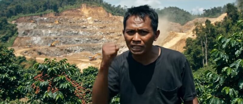
Gayo Lues, Aceh – A grayish, metallic-sheen puddle was first noticed by villagers one late afternoon in the protected forest area of Pantan Cuaca. The muddy water slowly flowed toward a small channel, eventually emptying into the Kenyaran River. Locals said the water had changed—cloudy, foul-smelling, and no longer safe for use.
The suspected source? A gold exploration project operated by PT Gayo Mineral Resources (GMR) in the middle of a protected forest zone in Gayo Lues. Visual evidence points to mud trails leaking from open boreholes with no proper sedimentation system in place. In some cases, the drilling sludge was seen spilling freely onto the ground, seeping into nearby streams.
No containment structures were seen at the exploration site. No storage ponds. No filters. No wastewater control system. The slurry appeared to flow directly into tributaries that supply water to downstream communities. This raised serious concerns about potential contamination from chemicals or heavy metals released during drilling.
ADVERTISEMENT

SCROLL TO RESUME CONTENT
“We are deeply concerned. The polluted water not only destroys ecosystems, but also endangers the people who rely on the river for their livelihood,” said Abdiansyah, Secretary of the Leuser Aceh Institute (LLA), during an interview on Friday, July 25, 2025. He stressed that GMR’s exploration activities cannot rely solely on formal licenses; the on-ground environmental impact must be closely monitored.
PT GMR holds an exploration permit issued by the Ministry of Environment and Forestry (MoEF) through Ministerial Decree No. 263/2025, allowing the use of protected forest areas for mineral drilling. However, official maps published in April place the GMR work zone right atop a mix of protected forests, limited production forests, and areas dangerously close to nature reserves.
“That area is a water catchment zone. It should be prioritized for protection, not used for gold exploration,” said Abdiansyah. He warned that unless authorities step in soon, the environmental damage could become permanent.
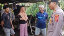
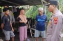
Villagers in Kenyaran and nearby downstream communities reported increased fears about water quality. “Sometimes it turns milky white, sometimes green, and it smells like iron. We’re afraid to drink it or even bathe,” said one resident, requesting anonymity. Some families have started collecting water from deeper inside the forest, no longer trusting the river near their homes.
Environmental experts warn that drilling wastewater must be carefully managed, as it can carry active minerals and heavy metal residues from deep underground. “If sulfide layers are pierced, arsenic or mercury can be released,” one scientist explained.
As of publication, PT GMR has not issued a statement. Multiple messages and calls to company contacts went unanswered. The local Environmental Agency (DLH) of Gayo Lues has also remained silent, despite receiving complaints from residents two weeks earlier.
Abdiansyah confirmed that LLA will soon submit formal complaints to the MoEF and the Indonesian Ombudsman. “We need an independent environmental audit. If toxic waste is leaking, this is a serious offense and potentially a criminal act,” he said.
On paper, PT GMR is conducting a legal exploration project with government approval. But on the ground, the reality is far removed from the corporate narrative. In the Tangsaran hills of Gayo Lues—an ecologically vital zone of the Leuser Ecosystem—this “authorized” exploration has raised grave questions. About legality. About ethics. About the future.
An investigation by the Leuser Aceh Institute has uncovered a web of inconsistencies hidden beneath corporate paperwork. The name “Lokop Gayo Lues Block” listed in PT GMR documents is misleading. The actual site is not in Lokop, East Aceh, but in Kenyaran Village, Pantan Cuaca District. Alarmingly, maps used by the company reference coordinates in North Maluku—over 3,000 kilometers from the true site. A geospatial anomaly that cannot be brushed off as mere error. “This isn’t just wrong coordinates. It’s manipulation meant to obscure the true location and mislead the public,” said Abdiansyah on July 25.
He questioned the legal basis for the exploration. “If the maps are false, and the coordinates bogus, how can this permit be considered legal?” He alleged that GMR’s actual drilling site directly encroaches on protected forests, limited production zones, wildlife sanctuaries, and even the core zone of the Gunung Leuser National Park—one of the last remaining tropical rainforests of Sumatra.
Environmental laws are supposed to serve as a barrier for fragile ecosystems like Leuser. But in the case of GMR, that barrier appears to have been dismantled from within. The project continues without a published Environmental Impact Assessment (AMDAL), without a Forest Area Utilization Permit (IPPKH), and without any transparent mapping or consultation with affected villages. Multiple regulations were violated: Forestry Law No. 41/1999, Environmental Law No. 32/2009, Mineral Law No. 4/2009, Government Regulation No. 104/2015, and MoEF Regulation No. P.27/2018. Not a single document has been publicly shown by the company.
Even more concerning, Kenyaran villagers say they were never informed or consulted. No town hall meetings. No announcements. No explanations. “The heavy machinery just showed up one day. The river changed color. The jungle went quiet,” one villager recalled. “We used to live off this forest. Now we’re just watching it being taken like thieves in the night.”
GMR’s headquarters are far from the humming machines and displaced wildlife. According to LLA, the company’s main office is located on the 8th floor of Bakrie Tower, Rasuna Epicentrum, Jakarta. From that air-conditioned skyscraper, exploration directives are issued—without a single word to the Indigenous communities who have safeguarded Tangsaran for generations.
The company’s claim of holding a valid two-year exploration permit raises further doubts. Not one document can be independently verified. “We’ve asked the authorities, but no one could provide the AMDAL. The map is fabricated, and no trace of the license exists. This whole permit should be considered fake or legally flawed,” Abdiansyah stated.
Field investigations reveal not only administrative violations and environmental harm, but also the deep social disruption imposed on Indigenous ways of life. As water becomes toxic and farmland degrades, the impact reaches far beyond nature—it strikes at the spiritual and ancestral bond between the people and their land.
LLA is now demanding that the MoEF, the Law Enforcement Center (Gakkum) in Sumatra, and the Governor of Aceh revoke GMR’s license. They call for a full audit of the permit process by the Ombudsman, and urge the Corruption Eradication Commission (KPK) to investigate potential collusion. “We suspect that government officials and corporate actors conspired to push this license through. If true, this constitutes corruption,” said Abdiansyah.
The report has also been forwarded to international organizations monitoring the Leuser Ecosystem, which forms part of the UNESCO-listed Tropical Rainforest Heritage of Sumatra. “This isn’t just a local conflict. It’s state-sanctioned destruction of a global treasure,” he said.
The GMR scandal illustrates how legal loopholes, bureaucratic negligence, and cartographic manipulation can be weaponized to legitimize the seizure of Indigenous land. If the government remains silent, if law enforcement turns a blind eye, history will remember that the Leuser forest was sold off in silence—without debate, without consent, without mercy.
Because anyone who sets foot in Leuser without ethics is, in truth, stepping on the neck of our shared future. (*)